Location
The Cerro Covadonga Project is located approximately 40 km north of the Cerro Vanguardia gold mine, operated by AngloGold Ashanti, in the centre of the Deseado Massif, Argentina (see Figure 1).
The Cerro Covadonga M.D. constitutes 2,945 hectares on which the Project is based.

Figure 1: Deseado Massif, Magna Terra Minerals Property Map.
Geology and History
The Cerro Covadonga Project is an early-stage exploration project characterized by gold-bearing, low-sulphidation veins and breccias, hosted in andesitic flows and rhyolitic tuffs of the Bajo Pobre and Chon Aike Formations. Most of the surface gold is concentrated in the discovery vein, Lomo Vetado, and Trincheras Zones. Epithermal veins, stringers, and breccias form a 600m by 150m gold-bearing footprint. The principal area of interest occurs on the western side of the Cerro Covadonga M.D. (see Figure 2). The zones discovered form a 3 km strike length, which the Company interprets to be a major dilatational jog.
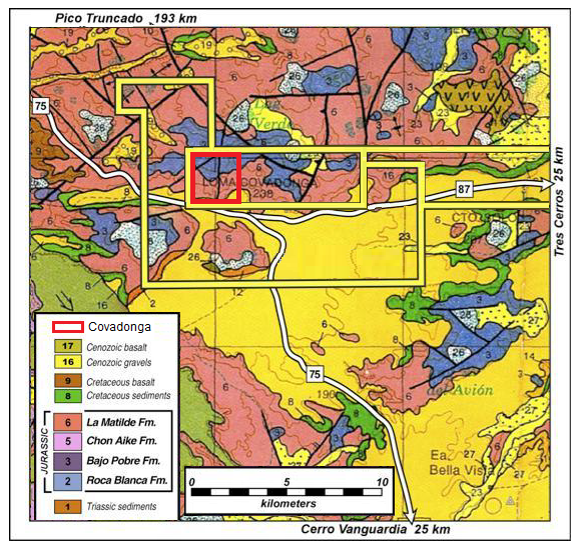
Figure 2: Location of the Cerro Covadonga project within the Covadonga property and relative to the regional geology and Cerro Vanguardia gold mine.
The Company has also identified a significantly larger mineralized footprint from rock chip and soil samples with anomalous Au, Lead (Pb), Arsenic (As), and Mercury (Hg) over a 3 km strike length in veins and hydrothermal breccias. Trenching (see Figure 3) has revealed anomalous Au with a very high correlation coefficient to Pb in argillic alteration in volcanic rocks. The alteration, mineralization, and geochemistry infer project outcrops are at or near the top of a low-sulphidation gold-silver system.
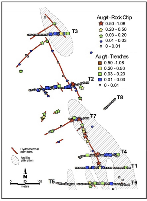
Figure 3: Trench map with hydrothermal corridors and surface gold assays relative to argillic alteration halo.
Work on the Project includes a 700+ soil sample campaign based on a 50m grid, which contributed to the mapping of the gold and geochemical footprint and supported the design of the ground magnetic and Induced Polarization blocks. Figure 4 illustrates a reduced magnetic pole overlain by gold in rock chips and soil.
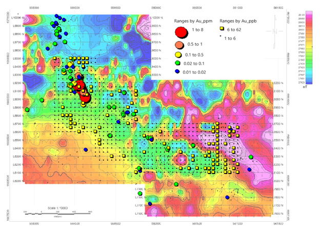
Figure 4: Reduced the Pole ground magnetics with rock chips and soil Au anomalies.
The orientation of veins varies significantly but generally ranges from north-northwest to west-northwest. This observation is consistent with the general west-northwest orientation of gold in soils and the same orientation of the magnetic low, which generally coincides with the gold-bearing area. The mineralization and alteration footprint measures approximately 1 by 3 km.
Opportunity