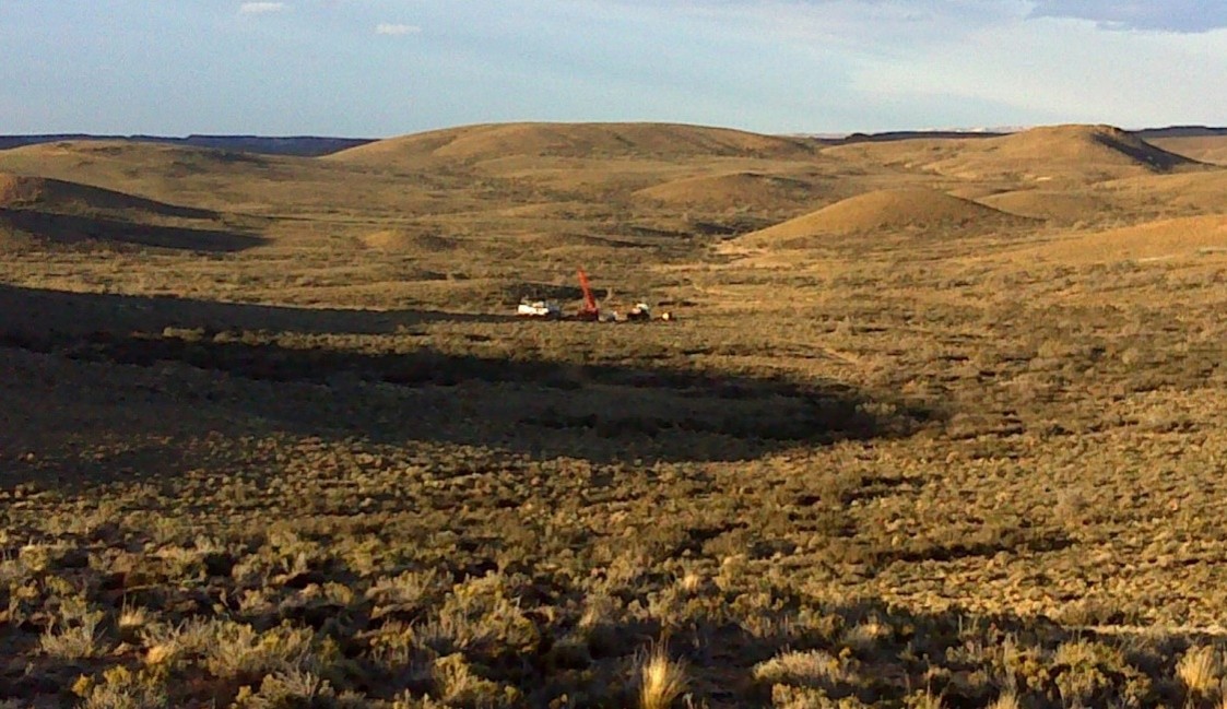
Location
El Meridiano, at 2970 hectares, is a proven gold-bearing system where modern geophysics has redefined the primary target, revealing a large, untested anomaly at depth. The El Meridiano Project is located in the Deseado Massif of Santa Cruz Province, Argentina (Figure 1), approximately 37 km northwest of the Cerro Vanguardia Gold Mine, operated by AngloGold Ashanti.

Figure 1: Deseado Massif, Magna Terra Minerals Property Map.
The Project is in the western part of an 8-10 km-wide caldera (see Figure 2), and the westernmost part of this feature is thought to be the site of a 2.5 km-wide circular diatreme complex. Virtually all samples from the breccias in the area contain small to significant amounts of gold, arsenic, and antimony, but very little silver or base metals, suggesting that mineralization is preserved at a high level of erosion.
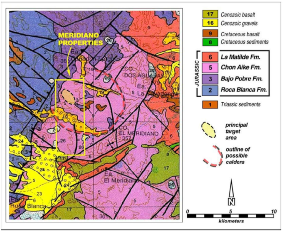
Figure 2: El Meridiano property boundary over regional geology map and illustrating the presumed Caldera boundary and the principal target area where most of the work to date has been carried out.
Geology and History
Prime Geological Setting: Located 37 km northwest of the Cerro Vanguardia gold mine (AngloGold Ashanti) the project features gold, arsenic, and antimony hosted in hydrothermal breccias, indicating the mineralized system is well-preserved at a high level.
The El Meridiano M.D. lies in the western part of an 8-10 km-wide caldera (see Figure 2 above), and the westernmost part of this feature is thought to be the site of a 2.5 km-wide circular diatreme complex. Andesitic to felsic tuffs in a 4 km2 area are cut by gold-bearing hydrothermal breccias filling north to northwest trending fractures and faults.
Drilling was carried out on the project in 2009 and 2010 by a previous operator. Work carried out included 403 rock chip samples, 65 line-km of magnetic and 32.5 line-km of gradient array IP ground surveys and 32 drill holes. The drilling totals 4,698 m in two reverse circulation campaigns and one diamond core twin-hole campaign. The drill holes were collared within a 1 km2 area in the northwestern corner of the property.
Historic drill results included multiple intercepts of gold mineralization. Ten holes intersected “significant mineralization” (see Figure 3) considered to be the equivalent of a minimum of 1.5 m (true thickness) of at least 0.34 ppm Au. The holes with significant mineralization constitute about one-third of the holes on the Project and tend to have wide intervals of low-grade mineralization interspersed with narrower higher-grade zones. Most of the holes on the Project hit at least some mineralization with one to several intervals of at least 0.10 ppm Au.
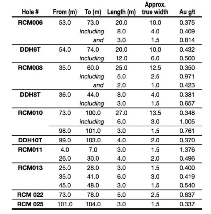
Figure 3: Historic drill results “significant mineralization” as defined in the Renaissance Gold Press Release dated Dec 20, 2010.
In 2017, Magna Terra carried out a CSAMT study with lines orientated northwest-southeast across the northeast-striking structures, which the Company believes form a principal control on mineralization.
7.5 line-km of CSAMT were used in three lines to give a clear idea as to the shape of the resistivity at depths down to 400 m. Figure 4 illustrates the CSAMT section 2, where a large triangular resistive anomaly occurs between two northeast-striking faults. The zones that have been drill-tested are shallow relative to the size of the resistive body, implying that previous drilling tested local gold-bearing fractures rather than the main northeast-striking faults. The Company believes that the flanks and base of the resistive anomaly represent the margins of a diatreme, the extent of which is controlled by northeast-striking faults. The Company now believes the preserved palaeosurface within a crater or vent, along with the controlling northeast faults, represents the main targets at El Meridiano.
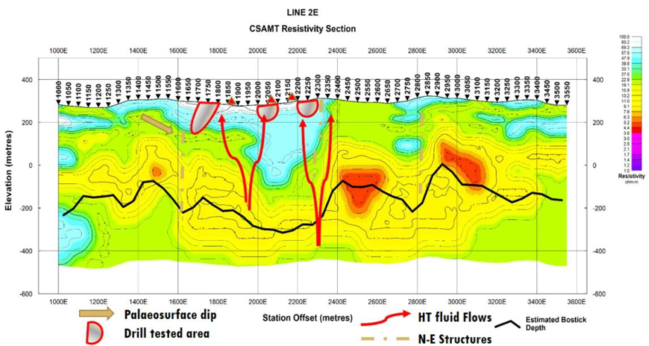
Figure 4: CSAMT Line 2 of 3 illustrating a large resistive zone beneath the already drill-tested areas.
Opportunity